 |
Track Mapping |
|
Track Mapping |
For motor racing applications, track mapping involves using the vehicle data logger and associated instrumentation as a simple inertial navigation system. The principle is best described as having a constantly varying velocity vector, with data for this recorded for every time increment of the data logger. The data logger velocity channel gives the magnitude of this velocity vector while the data logger lateral acceleration channel gives the basis for the direction of the velocity vector. Errors in the instrumentation readings can propagate rapidly, so very high quality instrumentation is required for best results. Typical instrumentation will give good results though there will be an appreciable error present. The track map generated will generally define a consistent set of data, but will probably not result in a dimensionally correct track layout. |
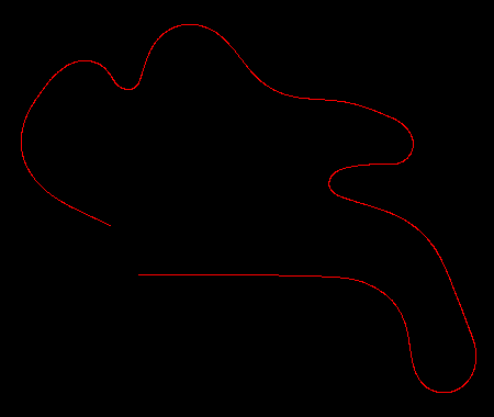 |
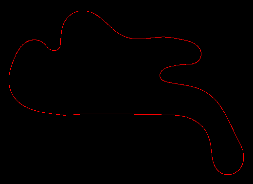
This image shows the raw data logger
information for a lap of Phillip Island. This raw data
analysis gives a track length of 4312 metres. The actual
lap length is 4450 metres. This indicates a scaling error
is present within the velocity data recorded. The track
path does not close due to instrumentation errors. |
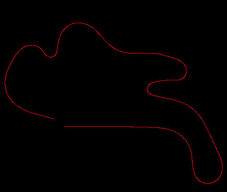 |
This image is the logger information
corrected for lap distance. This has been corrected to
obtain the revised map shown. Note how applying this
scaling factor has changed the entire shape of the map. |
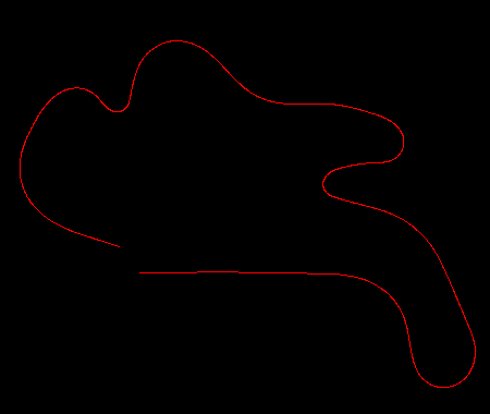 |
This image is a map from the raw
logger data, but with an offset added to the lateral
acceleration values. This has not yet had the distance
correction applied. The lateral accelerometer provides the heading value. This accelerometer can suffer from errors due to any minor misalignment in the car and also from scaling errors. Adding an offset value will compensate for the misalignment error. This value can usually be determined by trial and error. |
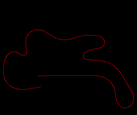 |
This image is a trace with both the
distance and offset corrections applied. The lateral
acceleration offset here has a value of 0.0105 and is
applied first, then the distance correction is applied. Changing the acceleration values after the distance correction could result in a change in the calculated track length, so the distance correction is applied last, in order that the true track length is obtained for the final data set. |
 |
This image is a trace with a smaller
lateral acceleration offset value of 0.00315 applied. As
can be seen when comparing this map with the preceeding
one, this map is much closer to the result where the
track path closes. Having the lap start and end at the
same point is the objective here. The lap should also
ideally have the same heading for the start and end
locations in order to obtain a consistent data set.
Iterating to a final value can be employed to obtain a
close approximation to the actual accelerometer offset
value. Note that no allowance has been made here for vertical variation in the track profile, so a perfect result should not be expected for that reason alone. Some combination of velocity correction (scaling factor) and lateral accelerometer correction (offset and scaling factor) should lead to a nearly closed track map. |
| Copyright (C) 2018 Temporal Images | Email Us | Last Updated: 1st November 2018 |